SERVICE LOCATING, CCTV PIPE INSPECTION & GPR IN BRISBANE AND SOUTH EAST QUEENSLAND
VAC2U offer an industry-leading range of underground service locating and CCTV pipe inspection services providing unmatched accuracy in mapping and protecting underground utilities. Utilising advanced ground penetrating radar technology and precision techniques our services are available across Brisbane and South East Queensland, delivering safe, non-destructive, and reliable outcomes for projects across the region.
What is Underground Service Location?
Underground Service Location or Utility Mapping is the use of state of the art radar technology to create an accurate map of the underground elements of a site. This process is crucial when working on or developing sites where the only site data available is old, out of date, of dubious quality or unavailable.
Don’t risk obstructing third-party underground infrastructure and running into damages costs. Use our state-of-the-art radar technology to map through the site prior to digging or excavating.

How Service Location works?
Using electromagnetic locating, ground-penetrating radar, Electro-Magnetic Induction and vacuum excavation techniques, our team can identify exactly what type of utilities are buried underground onsite and pinpoint their precise location, including the accurate depths of the utility and its orientation.
From electrical cables, concrete structures, water pipes and sewerage systems, VAC2U can locate and mark the locations of utilities throughout South East Queensland for future reference, available for whenever you want to begin building.
Why use Service Location?
Size doesn’t matter when it comes to safety. From digging a ditch in the back garden for gardening to digging trenches on large scale civil construction projects, all excavation projects big and small must ensure that site workers are safe during construction. Not only should workers be safe, but the local public should not be put at risk due to damaged utilities, such as through ruptured gas lines or striking electrical cables.
Having a clear picture of the sites underground before you start digging minimises the risk of potential cable and utility strikes that can cause damage to third party services and the residents of the area surrounding the site.
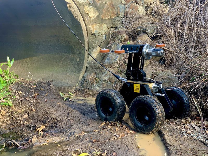
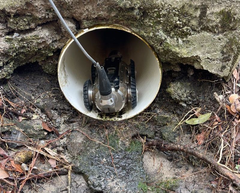
CCTV Pipe Inspection
CCTV pipe inspection is primarily used to determine the condition of underground conduits. This equipment collects photographic and video footage of defects and obstructions and we provide detailed reporting of findings. The team can provide CCTV inspection services that comply with the Water Service Association of Australia codes for 100mm up to the largest conduits. Our reports can be used for pre and post-construction requirements for build-over applications.
Tractor cameras can also be used to assist with locating pipes, chambers, gullies and maintenance covers that are concealed on the surface. This equipment works in tandem with our EMF locating equipment to pinpoint any defect or obstruction so that the repair can be carried out from above ground by excavation, or below ground utilising water jetting, with the minimum of disruption. Additionally, our camera can be used to enter a confined space that would normally require workers to enter, so this is a safer way to gather any information you require.
GPR Ground Penetrating Radar
It isn’t always possible to use EMF locating techniques to locate buried services. In fact, with EMF equipment alone, some assets are essentially undetectable. When we consider that some of these ‘hidden’ assets are either dangerous to those doing the digging and/or expensive to repair, it’s not good enough to leave them undetected and hope for the best.
GPR (Ground Penetrating Radar) systems enable operators to detect underground utilities, particularly non-conductive pipes and ducts, using high-frequency Radar. As such, GPR can be a valuable complement to EMF cable and pipe locators.
Precision in Protection of your Underground Assets
What areas do you service?
VAC2U provide utility mapping,
hydro excavation
and ground penetrating services across South East Queensland from the Sunshine Coast, Toowoomba and western regions, Brisbane and the Gold Coast down to Northern New South Wales.
Interested? Book a time with VAC2U for service location?
VAC2U offers its service location service, powered by our electromagnetic locating, ground-penetrating radar, electro-magnetic Induction and vacuum excavation techniques. Contact us on
0420 902 279
for all your enquiries on service location and ground-penetrating radar requirements.